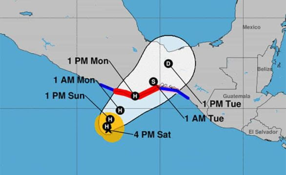
Tropical Storm Agatha was heading for the coast of Oaxaca on Saturday where forecasters predict it will become a hurricane by Sunday.
The first named storm of the Eastern Pacific this year has triggered a hurricane warning between Salina Cruz and Chacahua Lagoon, an area that takes in the tourist destinations of Huatulco and Puerto Escondido. A hurricane watch is in effect from Salina Cruz eastward to Barra de Tonalá.
The U.S. National Hurricane Center (NHC) said at 4:00 p.m. CT Saturday that the storm was located 270 kilometers southwest of Puerto Ángel, a town that is 65 kilometers east of Puerto Escondido. It is expected to strengthen quickly and become a hurricane Sunday morning and make landfall on Monday afternoon within the hurricane warning area.
The Weather Channel predicts the storm will make landfall close to Puerto Ángel.
Mexico’s National Meteorological Service forecast heavy rain in parts of Chiapas, Oaxaca and Guerrero starting Saturday afternoon, accompanied by a storm surge.
Forecasters at AccuWeather said Agatha would reach Category 1 hurricane strength by Sunday night. A factor contributing to continued strengthening is high water temperatures of 30 C.
AccuWeather predicts Agatha will make landfall as Category 2 (maximum sustained winds between 154 and 177 kph) on Monday evening.
Meteorologist Dan Pydnyowski said the hurricane’s biggest impact would be from rainfall. “The heaviest rain will fall across … Oaxaca and Chiapas, causing flash flooding mudslides and road closures.”
Coastal areas of Oaxaca and Chiapas can expected 200 to 300 mm of rain and mountainous areas as much as 710 mm.
The last hurricane to strike the Oaxaca coast was Carlotta, which made landfall near Puerto Escondido as Category 2 in June 2012. Seven people were killed and at least 29,000 homes and 2,500 businesses were damaged, mostly in Oaxaca.

No comments:
Post a Comment
Thank you. Comments are welcome.
ivan