https://nohaybronca.wordpress.com/2023/07/28/hiking-an-underground-river-in-mexico/
Hiking an Underground River in Mexico
Posted by Ted Campbell
An underground river – I didn’t know such a thing existed. But ok, it made sense. A river underground, right? Want to hike it? Sure, why not?
I imagined a winding tube starting from a modest crack in the earth, like an old-time mine shaft cut through rock. I imagined crouching and crawling, like when my middle school buddies and I explored a city sewer. My friend Pedro, who invited me, said it would take about six hours. Alright, let’s do it.

I definitely didn’t imagine a fast-flowing, waist-deep stream entering a huge vertical hole wider than the tunnel for a two-lane mountain highway. I didn’t expect to spend more than eight hours underground, to finally emerge at sunset from an equally large hole on the other side of a mountain. And I didn’t expect that, before all of this, we’d hike for two hours and then climb down a steep canyon cliff on a flimsy steel staircase just to get to the cave entrance.
About 150 kilometers southwest of Mexico City in central Mexico, the Chontalcoatlán River begins on the high slopes of the inactive Nevado de Toluca volcano. It travels though parched, desolate highlands of thick shrubs, scraggly trees, and tall cactus.
Above ground, it looks like a typical mountain stream. Cold clear water flows over submerged boulders and rocks, twisting and turning at the bottom of a dry valley so deep that you’d never see it unless you peered down from a bridge.

This large region of the Sierra Madre del Sur mountain range is neither cool plateau nor steaming valley, but something in between, a subtropical land of sand, sandstone, and tiny communities of concrete and sweat. These are the hidden corners of Mexico, far from cities or even proper towns. These are the corners that hide underground rivers.
The word Chontalcoatlán is a mouthful, so it’s often abbreviated to La Chonta. It’s named after the Chontal tribe, one of the many indigenous groups of central Mexico with distinct customs and languages. Currently fewer than 200 native speakers of Chontal remain, most living far away in the southern state of Oaxaca.
We began the adventure at the Grutas de Cacahuamilpa — the Cacahuamilpa Caves — a national park with chambers as big as soccer stadiums. A concrete footpath takes visitors deep underground into one of the largest cave systems in the world, so large and labyrinthine that native people hid in them after the Spanish conquest.
If you’d like to visit the Cacahuamilpa Caves in Mexico, you can take a cave tour from Mexico City, a cave tour from Taxco, or a cave tour from Acapulco.

Below the entrance to Cacahuamilpa’s cave passage is where the Chonta river exits the mountain, returning to daylight. At this same point another underground river, San Jeronimo, flows out of an equally large hole and joins the Chonta to form the Amacuazac River. It then makes the long trip to the Pacific Ocean.
These two holes are called Dos Bocas (Two Mouths), and they’re easily reached by hiking down the valley from the entrance to the Cacahuamilpa Caves.
At 12 km, the hike through the underground portion of San Jeronimo is not only longer but also much more treacherous than the eight kilometers La Chonta spends below ground. San Jeronimo is for experts only. Pedro told me that some sections of the underground river have whirlpools that can suck you down into who-knows-what below, lifejacket and all.
Seven of us would hike La Chonta today: Pedro, three of his co-workers — our leader Carlos and two others — and Carlos’s teenage son and his son’s friend.
Pedro and a few of the others had done the hike before, but Carlos was our leader because he’d done the hike almost every year for the past 20 years. His first time was with a high school group.

After breakfast in the small market at the entrance to the Cacahuamilpa Caves National Park, Carlos hired a pickup truck to take us to the trailhead high in the mountains. We would exit the underground river at Dos Bocas right next to Cacahuamilpa, but first we’d need to get to the opening of the cave, by truck and then on foot. I knew the highway well, having ridden it on my bicycle many times, but I’d never noticed the small turnoff about 15 minutes by car from the caves.
We hiked for about two hours, first along a mountain ridge though a forest of leafless trees and shrubs. It was dry season — the reason we were going in February. The hike is impossible during the summer rainy season when the river and rapids are high.
Carlos and his friends chose early February to beat groups of students and boy scouts who leave their garbage inside, which the summer rains eventually wash away every year. At one point in the cave I saw a car tire stretched and jammed down to the bottom of a long, pointy piece of rock, a testament to how powerful the river is during rainy season.
I wore a swimming suit, a quick-dry t-shirt, a lifejacket, and stiff-soled hiking boots. I was glad for the boots many times that day, even though one of them eventually fell apart. A few people in our group had tennis shoes, and I often saw them wince as they bashed their feet on submerged rocks. Even with hiking boots, my feet and ankles were brutalized by the end of the day.
I also carried a small backpack that held two headlamps, two sandwiches, and a bottle of water. Slung to the backpack was an old bicycle helmet that I’d wear once in the cave.
We crossed the high ridge of the mountain range and began to descend. The trail got steeper as it curved downward, with large stones in the path among the sand. The trail entered the morning shade of the valley and suddenly the trees were full of green. Soon we were crawling over boulders and gripping branches for support. The trail ended at a cliff. A thick metal cord, lightly rusted with age, was bolted to a rock above the cliff.
Carlos climbed down first, disappearing below the rocky ledge. Then one by one we went down. I was the second to last. The metal cord held firm and there were plenty of footholds.
As I stepped down the cliff, Carlos came into view below. He wasn’t on the valley floor, but on a narrow ridge above another cliff. From here an old metal ladder began that was much longer than the cord. Halfway down it too went out of sight under the cliff.
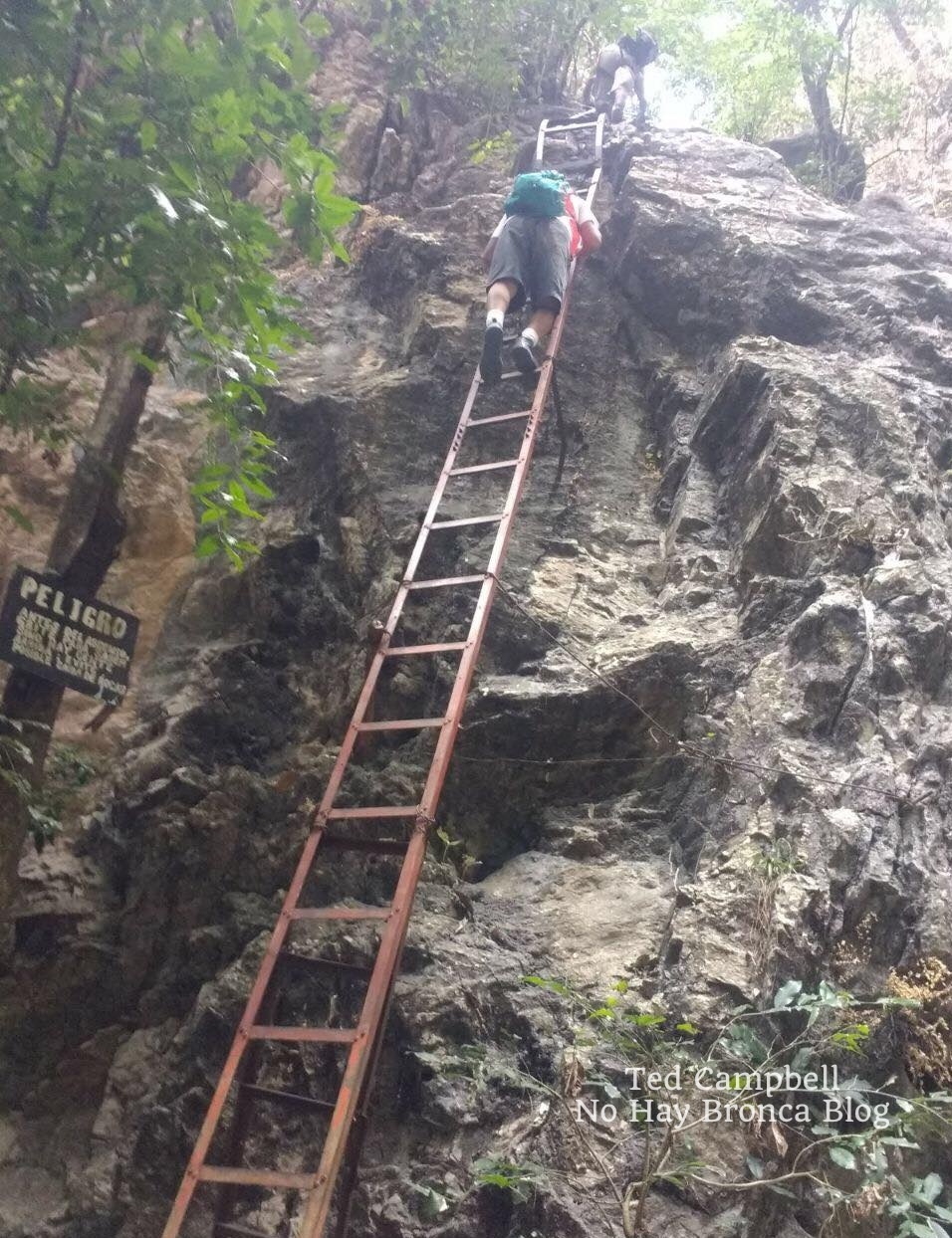
The ladder shook and shifted as I climbed down it. A few rungs were missing, broken away. While placing hand below hand, foot below foot, I thought about Pedro above me, waiting until I got to the bottom before he started climbing down.
I thought about the large group we’d passed earlier on the trail. They’d climb down next, all ten or so of them, one after another. And after them more groups would come during the two or three months of continuing dry season.
They’d all make it down. The ladder would hold. And with that, I landed. My feet were firm on the rocky riverbank. For the first time I had a clear view of the humungous hole and thought, wow.
The opening to the underground river was a vertical crater rimmed in white with sheer cliffs above. You could see that, instead of continuing on between the mountains, the forces of water that had formed this deep valley — I’d call it a canyon or gorge if it weren’t so covered in shrubs and trees — hit a dead end here. Somehow the crater was hollowed out, sucking water into it like the drain on a locker room floor.

We sat under the high cliffs and had an early lunch before entering. The chamber at the opening was large as an airplane hanger, with calm water below that flowed into total darkness.
The shakiness I felt from climbing down the adder finally left me. I half-expected to jump right in the water and start floating downstream, but instead we walked on the sandy banks, climbing over boulders strewn about. It didn’t take long until the faint light from the big hole behind us finally disappeared and the only light was from our headlamps and flashlights.
When we came to impassable cliffs, we’d wade across the underground river to the other side, initially going no deeper than our thighs. The water was cold. When the current ran quickly, we’d all hold hands as we stumbled across.
Carlos was always in the lead, picking the best route. He told me later that nothing was as he remembered it. The two powerful earthquakes that shook central Mexico in the fall of 2017 had moved everything around.
(I finally got around to posting this story in 2023 but did this hike in 2018.)
The cavern walls and ceiling were covered with intricate limestone structures. Delicate ridges of sparkling mini-crystals dripped like melted cheese frozen to stone. False turns in stagnant pools of water had thick films of brown and green that released a rotten stench as we waded through them. We stopped at one point and turned off our flashlights. The darkness was complete—you couldn’t see your hands in front of your face.
After several hours of this we reached a chamber so big that the flashlight beams vanished overhead. We stood on a wide gravel beach. Next to the cavern wall was a foot-tall statue of the Virgin Mary in a metal cage, decorated with colorful plastic flowers and surrounded by the remains of burnt candles. The metal cage was deeply rusted and the statue was coated in black soot from the candles.
Nearby on the rock was a large plaque in recognition of one of the underground river’s early explorers, who’d recently died of old age, not in the cavern as I first assumed. By how worn it was, the plaque looked ancient, but it had been erected only five years earlier.
Carlos said there were interesting places to explore here. We walked across the gravel and scrambled up some boulders. We took off our lifejackets and backpacks, leaving them on the rocks. A rope hung down from a cliff. We took turns climbing up into the dark unknown.
At the top of the cliff was a flat platform of smooth stone. The ceiling was still far above and out of flashlight range, even though we’d already climbed higher than a two-story building. We walked around a corner to an area enclosed in high walls of jagged stone. Pointy, delicate stalactites hung from above. Carlos shone his headlamp down to where the cavern wall met the floor, into a hole no bigger than the opening of a washing machine.
“We can climb in there,” he said, getting on his knees. He adjusted his headlamp and crawled in headfirst, slithering like an iguana, his boots dangling behind as he pushed himself into the hole.
His son went next. Then me. The ground was heavy mud that protected my elbows and knees from the hard rock, although they were unavoidably scratched a few times. Occasionally I could lift my head and look around, but in most parts the rock was so close that my chin dipped into the mud below and my helmet banged against the rock above.
The tiny tunnel went up, then to the side, then down, then up again. One downward section was a steep slide headfirst into the mud. It was more open at the bottom, and I could get up on my knees. Carlos’s son sat there with the mud above his hips, eyes wide, breathing hard—clearly terrified.
“I’m going back,” he said. He called down the cave to his father, “I’m going back.” I couldn’t hear Carlos’s muffled reply. His son squeezed passed me and scrambled up the rock I’d just slid down.
That’s when I felt it—the closeness of the walls, the staleness of the air, the feeling of being utterly trapped and helpless. If I panicked, then I’d be truly trapped—there was no rushing out of this cave. The only way out was a slow, patient crawl through even tighter rock, following Carlos’s son. I took a deep breath of the muddy air, reminding myself that panic was the only enemy. Or another earthquake…
It was warm, at least. I wasn’t shivering for the first time since getting into the underground river hours ago. Calm, I told myself, be calm. At that moment Pedro came down the slide and splashed into the mud next to me.
“I’m going back,” I said. “Ok,” he replied. He squeezed past me toward Carlos deeper in the cave.
I looked at the soles of Pedro’s boots slipping out of sight, then in the other direction up the slide toward the exit, then back at the hole where Pedro’s boots had been. Ah, what the hell, I thought, and followed him.
We crawled about twice as deep again to another chamber, this one as spacious as the bathroom on a Greyhound bus. Carlos was waiting for us there. He pointed to where the cave continued on the high opposite side of the chamber. It would be the tightest squeeze yet.
“After about two hours, it reaches an underground lake,” Carlos said.
“You’ve been to the lake?” I asked.
“Sure, many times.” He pointed to a crude clay sculpture of a man with a large erect penis on one side of the chamber. “My friends made that the first time I came down here, when I was in high school.”
“Two hours?” I asked.
“Yes, about two hours. We can’t go now, not enough time. We can do it next time.”
“Two hours in a tunnel like this one we just went through?”
“Most of it’s even smaller,” he answered.
An underground lake. Where? Why? How? It wasn’t part of the river, it was just there. What an incredible sight. I imagined spending two more hours in this tight passage with its tight air. Would I make it? That was a question for another day.
We turned around and started crawling out. The claustrophobia stayed with me, lingering on, but at least I knew where I was headed.
Squeezing into the cold air felt like being born, or more accurately, considering all the mud, defecated.

We were coated from head to toe. The ones who hadn’t gone in the hole stood around rubbing their hands together for warmth. Two hopped up and down, shaking off drops of water. They’d been waiting all the while we crept deeper underground and were still soaking wet. Using the rope, we climbed down the cliff and rinsed off in some rapids.
We spent the next hours scrambling over tall rocks on the riverbank, trekking over gravel mini-beaches, and wading across the underground river when necessary. Now it was often deep enough that we finally went in up to our lifejackets, but we could usually still touch bottom. The cavern turned and twisted with the river, sometimes opening into high chambers, but never anything close to as large as the one where we’d stopped.
All of a sudden, an eerie glow appeared downstream. It grew larger as we approached. We took a turn and there it was, a massive hole in the earth far above the biggest chamber yet.
This was the second entrance to La Chonta, an opening called the Hoyanco del Chanchuyo (Chanchuyo’s pothole), aka la Ventana (window) or Claraboya (skylight). At roughly the halfway point of the underground river, this is a common entrance for explorers with less time or ambition than us.
It’s also a popular rock climbing spot because of the many routes on the high side of the hole. From the river it looked like the passageway from the underworld back to the living world.
Thick beams of sunlight shone into the open cavern. Here the underground river ran around big boulders and though sections of fast rapids. We sat on a section of rocks not coated with swallow droppings, ate our remaining food, and rested for about 30 minutes, while watching two people carefully scramble down the slopes from above.

Once we started hiking again, full from the food but cold from the inactivity, it didn’t take long for all the light from the hole to vanish, after only a few twists and turns. The cave was narrower here, about as big around as a subway tunnel. The smaller space meant fewer gravelly banks, bigger boulders, and deeper water. So during these final three or four hours we spent much more time in the water. It was usually deep enough that we had to swim.
To protect our knees from submerged boulders, we held our feet in front of us as we floated downstream, paddling with our hands. It was cold but a nice change from constantly slipping and scrambling in boots heavy with sand and water. Near the end I was so exhausted that the freezing water felt like a wonderful feather bed all around me. The cold became a comfort.
In some sections, there was no riverbank at all, just sheer walls on both sides. I often held Pedro’s hand through these. He couldn’t swim, although he floated in a lifejacket well enough. But when the current picked up, or when we started bumping into underwater rocks, the motion would flip him over, submerging his head. He’d struggle to float on his back again, splashing in the black water.
Each time I could see the fatigue in his eyes, along with something else—not fear, more like dread. But then, each time, his eyes would meet mine, his face would break into a smile, and he’d lift his hand and give me a thumbs-up.
Another light appeared before us. The exit, finally. Bats and swallows swarmed overhead. Warm fresh air flowed into the hole. Peering over the boulders, I saw the green of trees and shrubs. Green meant life, and life meant escape.
We pulled ourselves out of the water, panting and dripping in the half-light. Carlos scrambled over piles of stone on both sides, looking for a route out, and announced that we’d have to float out. The routes he remembered were gone.
So we floated down the rapids, first under the high cavern roof and then under the big blue sky, with tall overgrown valley walls on both sides. The water was a muddy brown, and it seemed even colder in the open air. We reached a sandy bank and looked to our left at another hole, equally large—the exit for the San Jeronimo River. We’d made it.

The sun began to set by the time we’d knocked the sand from our boots and poured the water out of our backpacks. The concrete path from the river up to the national park entrance was steep and long, but easy compared to everything else we’d hiked that day. The ground was solid, at least, and dry. By now, the sole of one of my boots had come loose. It flopped loudly with a slurping sound of water as I hiked uphill.
It was dark when we made it to the empty parking lot, where we changed clothes in a bathroom. We began the long drive back home, with a stop for tacos of course.
Hiking a subterranean river wasn’t what I expected. Besides excitement and adventure, there was awe, fear, and exhilaration unlike anything I’d ever experienced. In the tightest tunnel, it was a rush of claustrophobia, and in the biggest chamber, it was a reminder of the ant-like insignificance of the individual human.
It was also a lot of fun. And a big part of that fun—a big part of that awe—was the glimpse into the deep, dark, mysterious world below us. Once you get that glimpse, it’s unforgettable.

IF YOU WANT TO GO
Unless you’re fortunate enough to be invited by friendly and experienced locals, like I was, you’ll need to find a guide. Don’t attempt the trip by yourself. You’ll get lost, if not in the underground river then on the hike to get there.
The trail to the entrance of the underground river has many others branching off from it, and of course the underground river itself moves through total darkness with countless possible routes and dead ends.
If you find a guide and are going into the underground river, wear hiking boots. You may end up ruining your boots like I did, but that’s better than ruining your feet.
Whatever you bring, pack it in several waterproof cases. If you bring a camera, carry it in a hard case, or risk it being bashed on the rocks, like your knees and elbows.
The time to hike through the underground river is the dry season in spring, particularly March and April.
The nearest town is Taxco, which is one of the most beautiful small towns in Mexico. Its colonial-era buildings, all painted white, are scattered over mountain slopes and connected by twisting cobblestone streets and narrow alleys.
Taxco isn’t far from Mexico City and it’s a good place to inquire about the Chonta hike. If nothing else, from Taxco you can easily visit the Grutas de Cacahuamilpa National Park and its enormous, impressive chambers. Be sure to hike down the valley to check out Dos Bocas, where the two rivers flow out of the mountain.
Recommended Mexico Cave Tours
There are many caves in Mexico you can explore. Please note that these Mexico cave tours don’t go through the underground river that I described in the story above, but a few of them go to the Grutas de Cacahuamilpa National Park, which has some of the best caves in Mexico.
You can take a Cacahuamilpa cave tour from Mexico City, Taxco, or Acapulco.
The easiest and most affordable way to get to Cacahuamilpa is from Taxco. Click here for more information about this Mexico cave tour.
You can also do a Cacahuamilpa cave tour from Mexico City. On this 11-hour trip, you’ll explore Taxco after spending some time in the Cacahuamilpa caves.
A third option to visit Cacahuamilpa is from Acapulco. This 7-hour Mexico cave tour also takes you to some interesting attractions in Taxco.
Perhaps the most famous caves in Mexico are the Tolantongo Caves. Tolantongo aren’t only caves, but also hot springs. Click here for information about a Mexico cave tour to the Tolantongo Caves.
Chiapas also has some of the best caves in Mexico. If you’re in San Cristobal de las Casas, check out this Mexico cave tour to three places: Arcotete, Mamut & Rancho Nuevo.
Finally, some of the best Mexico caves are the cenotes of the Mayan Riviera. Scuba diving in cenotes is absolutely one of coolest things I’ve done in Mexico, right up there with the underground river hike I described in the story above. Click here for a good cenote tour that also stops at the Mayan ruins of Tulum.
This page contains affiliate links, which means I earn a small commission if you purchase something after clicking a link on this site. I receive this commission at no additional cost to you.