Hiking the Huge Mountains of Mexico City: Izta-Popo National Park
Posted by Ted Campbell
Unless you’re looking out of an airplane window, you might not even notice that Mexico City is surrounded by mountains, including the second and third highest in the entire country. You can see the green slopes and sometimes snow-capped peaks off in the distance when you finally escape the dense neighborhoods of the mega-metropolis.
At least ten national parks are within driving distance of the the city, meaning hiking trails, ziplines, ATM rentals, old ruined convents, waterfalls, caves, and expanses of pine forest. You might even get lucky and see animals like weasels, the tiny teporingo rabbit, white-tailed deer, long-tailed wood partridges, horned lizards, tarantulas, and rattlesnakes. Don’t be afraid of these last two–they’ll leave you alone if you leave them alone.
What you should make you cautious, however, are badly-marked trails and some safety issues, especially robberies. So if you want to go hiking near Mexico City, go in a group, stay on the most obvious trails, and come prepared with rain gear, layers of warm clothing, food, and lots of water. Also, choose a national park where you must pay an entrance fee and can park in an official parking lot, which will greatly reduce (if not eliminate) the possibility of criminals on the trail.
If the trail takes you high into the mountains, even better. For all these reasons, Itza-Popo National Park is probably the best for a day of hiking near Mexico City. I’ll write about other places in later posts, like the Cubres de Ajusco and Nevado de Toluca national parks.
You’ll need a car to get to there, or else pay for a long taxi or uber ride. Driving there is straightforward–just follow directions on Waze or Google Maps to the Paso de Cortés (Cortés’s Pass), where the park entrance is located. Get up early; the best light for photographs is in the morning, and rain is most likely in the afternoon, especially in summer.
Izta-Popo National Park
The two tallest mountains next to Mexico City, which are also the second and third highest in the country, are actually volcanos, one active and one long extinct. Active Popocatépetl has that classic cone with a wisp of smoke coming from the crater, while Iztaccíhuatl has a rocky, broken peak that gives few obvious clues to its volcanic origins.
Both of these pre-Hispanic names are quite a mouthful, so they’re usually abbreviated as Popo and Izta (pronounces EES-ta). They were revered as gods by the native Mexica, along with neighboring peak Tlaloc, named after the rain god.
In the Nahuatl language, Popocatépetl means “mountain that steams,” as it’s been active since ancient times. Iztaccíhuatl means “white woman”–like many mountains in the world, people have identified the features of a reclining body in its crags and cliffs.
Popo is off-limits to hiking because of regular activity; big eruptions happened most recently in 2000 and 2005, and it ejects long columns of smoke nearly every day. So the spot for hiking is on Izta, a long, arduous and high-altitude hike that’s only for the experienced and in good shape.
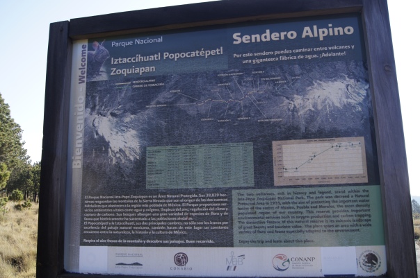
A less difficult hike is the Alpino trail, which follows the saddle between the two mountains. It begins at the parking lot at the entrance to the park and ends at La Joya, the name for the area that has the parking lot for the trail up Izta. Cars can take a winding dirt road to La Joya; the Alpino trail is roughly parallel to it but follows a higher ridge, with the road mostly out of sight.
Hiking Alpino takes about two hours each way, there and back, and has great views of both mountains. If you have enough time, you can continue up the trail to Itza for an hour or two for more great views and a taste of big-mountain experience.
When you arrive, first visit the park office to register and pay the 57-peso per-person fee. Then you can decide whether to start on the Alpino trail right there or continue driving to La Joya, where the hike up Itza begins.
The park office is located at the Paso de Cortés (Cortés’s Pass), named after the Spanish conquistador Hernán Cortés, who crossed it in 1519 after leaving Cholula, the nearby pre-Hispanic capital where he and his men had slaughtered between 5,000 and 6,000 people. Legend has it that, on the way, some of his men climbed Popo to collect sulfur for gunpowder for their canons and rifles. Then they descended into the Valley of Mexico to eventually conquer Tenochitlan, the island city that’s now the central part of Mexico City.
Yes, it’s a long story, and a fascinating one.
Today, a bumpy dirt road leads down the mountain slopes from the Paso de Cortes to Cholula, one of the most attractive towns in the area, with its yellow church built atop a massive, mostly unexcavated pyramid that resembles a hill. So, a nice two-day trip is an early morning hike in the national park, a twisty downhill drive to Cholula, and an evening and next morning exploring the town. You could also visit the city of Puebla right next to Cholula, making for a weekend of dramatic nature, pleasant towns, great food, and astounding history.


