Translate

A little about Playa Zipolite, The Beach of the Dead . . .

Playa Zipolite, Oaxaca, Southern Mexico, on the Pacific Ocean. A little bit about my favorite little get-away on this small world of ours.

Zipolite, a sweaty 30-minute walk west from Puerto Angel, brings you to Playa Zipolite and another world. The feeling here is 1970's - Led Zep, Marley, and scruffy gringos.

A long, long time ago, Zipolite beach was usually visited by the Zapotecans...who made it a magical place. They came to visit Zipolite to meditate, or just to rest.

Recently, this beach has begun to receive day-trippers from Puerto Angel and Puerto Escondido, giving it a more TOURISTY feel than before.

Most people come here for the novelty of the nude beach, yoga, turtles, seafood, surf, meditation, vegetarians, discos, party, to get burnt by the sun, or to see how long they can stretch their skinny budget.

I post WWW Oaxaca, Mexico, Zipolite and areas nearby information. Also general budget, backpacker, surfer, off the beaten path, Mexico and beyond, information.

REMEMBER: Everyone is welcome at Zipolite.

ivan

Sunday, May 29, 2022

Hurricane warning issued in Oaxaca as Tropical Storm Agatha gains strength

Hurricane warning issued in Oaxaca as Tropical Storm Agatha gains strength


Hurricane warning issued in Oaxaca as Tropical Storm Agatha gains strength
 
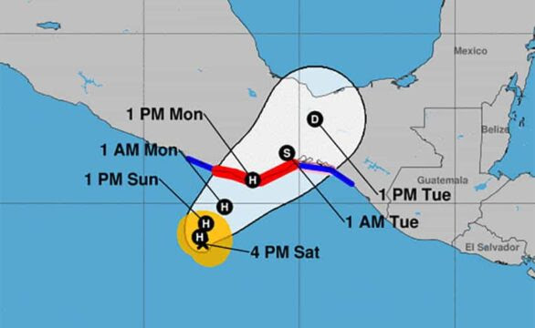
Tropical Storm Agatha was heading for the coast of Oaxaca on Saturday where forecasters predict it will become a hurricane by Sunday.


Tropical Storm Agatha was heading for the coast of Oaxaca on Saturday where forecasters predict it will become a hurricane by Sunday.


The first named storm of the Eastern Pacific this year has triggered a hurricane warning between Salina Cruz and Chacahua Lagoon, an area that takes in the tourist destinations of Huatulco and Puerto Escondido. A hurricane watch is in effect from Salina Cruz eastward to Barra de Tonalá.


The U.S. National Hurricane Center (NHC) said at 4:00 p.m. CT Saturday that the storm was located 270 kilometers southwest of Puerto Ángel, a town that is 65 kilometers east of Puerto Escondido. It is expected to strengthen quickly and become a hurricane Sunday morning and make landfall on Monday afternoon within the hurricane warning area.


The Weather Channel predicts the storm will make landfall close to Puerto Ángel.


Mexico’s National Meteorological Service forecast heavy rain in parts of Chiapas, Oaxaca and Guerrero starting Saturday afternoon, accompanied by a storm surge.


Forecasters at AccuWeather said Agatha would reach Category 1 hurricane strength by Sunday night. A factor contributing to continued strengthening is high water temperatures of 30 C.


AccuWeather predicts Agatha will make landfall as Category 2 (maximum sustained winds between 154 and 177 kph) on Monday evening.


Meteorologist Dan Pydnyowski said the hurricane’s biggest impact would be from rainfall. “The heaviest rain will fall across … Oaxaca and Chiapas, causing flash flooding mudslides and road closures.”


Coastal areas of Oaxaca and Chiapas can expected 200 to 300 mm of rain and mountainous areas as much as 710 mm.


The last hurricane to strike the Oaxaca coast was Carlotta, which made landfall near Puerto Escondido as Category 2 in June 2012. Seven people were killed and at least 29,000 homes and 2,500 businesses were damaged, mostly in Oaxaca.

COURT AT 11:40 PM, MAY 28 - SHELTER FACILITIES ALREADY SUPERVISED IN POCHUTLA Civil Protection and Municipal Education have already toured the first shelters set up as a prevention for Tropical Storm Agatha. Being mainly schools, the facilities were supervised to be adequate, with functional toilets and secure windows. We share to citizens: 🏠Ana Luz Toledo Shelter (next to the Regional Hospital) / 9581181808

CORTE A LAS 11:40 PM, 28 DE MAYO - INSTALACIONES PARA ALBERGUES YA SUPERVISADOS EN POCHUTLA
Protección Civil y Educación Municipal ya recorrieron los primeros albergues habilitados a manera de prevención por la Tormenta Tropical Agatha.
Siendo principalmente escuelas, se supervisó que las instalaciones fueran adecuadas, con baños funcionales y ventanas seguras. Compartimos a la ciudadanía:
🏠Albergue Ana Luz Toledo (a un costado del Hospital Regional) / 9581181808
🏫Escuela Primaria 12 de Octubre, Tahueca / 9581184258
🏫Escuela Primaria Emiliano Zapata / 9581071858
🏫Escuela Melchor Ocampo, Agencia Municipal de Puerto Ángel / 9581165151
🏠Casa de la Cultura "Profesora Petra Valle" / 9585857374
🏫Escuela Primaria José María Morelos, Colonia Chapingo / 9581102108
🏫Escuela Primaria Lázaro Cárdenas, Sección Segunda / 9585893744 - 9581072691
🏫Escuela Primaria Octavio Paz, Barrio Mendillo / 9581872161
🏫Escuela Presidente Juárez, Sección Cuarta / 9581002637
🏫Escuela Primaria Adolfo López Mateos, Loma Cruz / 9581070971
🏫Escuela Primaria Rural Benito Juárez, Los Reyes Chacalapa / 5523237702 - 9581747836
🏫Telesecundaria, Los Reyes Chacalapa- 9581744018
🏠Agencia Municipal de Benito Juárez, Benito Juárez / 9581000838
🏠Biblioteca Municipal de San José Chacalapa / 9581169247
⛪️Capilla de la Agencia Municipal de San José Chacalapa / 9581311253
🏫Escuela Primaria Minerva, San José Chacalapa / 9581311253
🏠Telesecundaria de San José Chacalapa / 9581311253


2 rooms for rent with internet service, water, electricity, bathroom, kitchen, terrace and shared room...!! Fair prices per day, week or month..!! We are located in puerto angel highway to the radar in front of the cecyte...!!! Interested send inbox or contact cel:9581223717😉👌👀

Natalia Zareth Montera is feeling excited.

Se rentan 2 cuartos con servicio de internet, agua, luz, baño cocina terraza y estancia compartida..!! Precios justo por dia semana o mes..!! Estamos ubicados en puerto angel carretera al radar frente al cecyte..!!! Interesados mandar inbox o comunicate al cel:9581223717😉👌👀


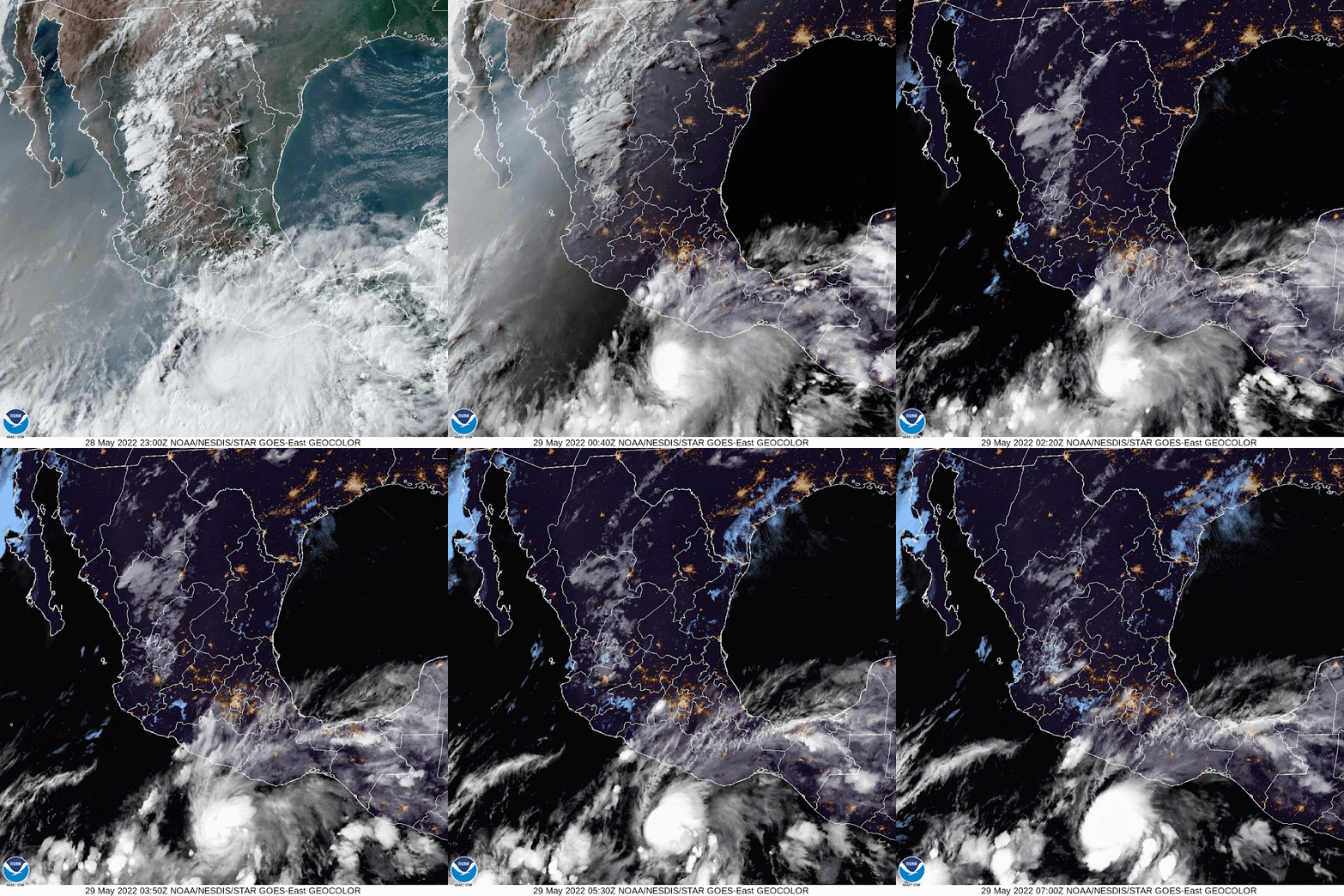
NHC Storm Description: 29 May 2022 - 6:00 UTC ...AGATHA EXPECTED TO BECOME A HURRICANE LATER TODAY... ...TODAY IS YOUR LAST DAY TO PREPARE BEFORE THE WINDS INCREASE...

NHC Storm Description:

29 May 2022 - 6:00 UTC ...AGATHA EXPECTED TO BECOME A HURRICANE LATER TODAY... ...TODAY IS YOUR LAST DAY TO PREPARE BEFORE THE WINDS INCREASE... As of 1:00 AM CDT Sun May 29 the center of Agatha was located near 14.0, -98.7 with movement NNW at 3 mph. The minimum central pressure was 998 mb with maximum sustained winds of about 60 mph.

https://www.star.nesdis.noaa.gov/goes/floater.php?stormid=EP012022&fbclid=IwAR1jQgPlaAXd1TXJ4ga2AQATivBh1anH5NjbpxGSShwWXyvnACWUU4kwKxc


Saturday, May 28, 2022

I rent a room for June 7, internet, private bathroom, shared kitchen $4000 100 m from the beach #zipolite and #PlayaDelAmor

Rento habitación para 7 de junio , internet, baño privado, cocina compartida $4000 a 100 m de la playa #zipolite y #PlayaDelAmor 


...AGATHA IS GRADUALLY STRENGTHENING IN SOUTHERN MEXICO... ...HURRICANE AND TROPICAL STORM WARNINGS ISSUED...


BULLETIN

Tropical Storm Agatha Warning Number 4

NWS National Hurricane Center Miami FL EP012022

400p m. CDT Saturday May 28, 2022

...AGATHA IS GRADUALLY STRENGTHENING IN SOUTHERN MEXICO...

...HURRICANE AND TROPICAL STORM WARNINGS ISSUED...

SUMMARY OF 400 PM CDT...2100 UTC...INFORMATION

----------------------------------------------

LOCATION...13.8N 98.1W

APPROXIMATELY 170 MI...270 KM SW OF PUERTO ANGEL MEXICO

MAXIMUM SUSTAINED WINDS...60 MPH...95 KM/H

CURRENT MOTION...NNW OR 345 DEGREES AT 5 MPH...7 KM/H

MINIMUM CENTRAL PRESSURE...998 MB...29.47 INCHES

WATCHES AND WARNINGS

--------------------

CHANGES WITH THIS NOTICE:

The Mexican government has issued a Hurricane Warning from Salina Cruz to Lagunas de Chacahua, with a Tropical Storm Warning and a Hurricane Watch from Salina Cruz to Barra De Tonalá, and a Tropical Storm Warning for Barra De Tonalá to Boca de Pijijiapan and of

Lagoons From Chacahua to Punta Maldonado

SUMMARY OF WATCHES AND WARNINGS IN EFFECT:

There is a hurricane warning for...

* Salina Cruz to Lagunas de Chacahua

A Hurricane Watch is in effect for...

* Salina Cruz to the east to Barra De Tonalá

A Tropical Storm Warning is in effect for...

* Salina Cruz to the east to Boca de Pijijiapan

* Lagunas de Chacahua to the west to Punta Maldonado

A hurricane warning means that hurricane conditions are expected somewhere within the warning area. A warning is generally issued 36 hours before the first anticipated occurrence of tropical storm force winds, conditions that make outside preparations difficult or dangerous. Preparations to protect life and property must be expedited to completion.

A Hurricane Watch means that hurricane conditions are possible within the watch area. It is normally issued 48 hours before the anticipated first appearance of tropical storm force winds, conditions that make preparations difficult or difficult outside dangerous.

A tropical storm warning means that tropical storm conditions are expected somewhere within the warning area within 36 hours.

Interests elsewhere in southern Mexico should closely monitor Agatha's progress.

For specific storm information in your area, check products issued by your national weather service.

DISCUSSION AND PERSPECTIVE

----------------------

As of 400 PM CDT (2100 UTC), the center of Tropical Storm Agatha was located near latitude 13.8 North, longitude 98.1 West. agatha is moving toward the north-northwest near 5 mph (7 km/h). A turn to the northeast is forecast to occur late tonight or on Sunday.

On the forecast track, the center of Agatha will approach the

Mexico's southern coast on Sunday and make landfall there on Monday.

Maximum sustained winds have increased to near 60 mph (95 km/h) with higher gusts. Rapid intensification is forecast and Agatha could become a hurricane by early Sunday morning.

Tropical storm force winds extend outward up to 70 miles (110 km)

From the center

The estimated minimum central pressure is 998 mb (29.47 inches).

THREATS AFFECTING THE EARTH

----------------------

WIND: Hurricane conditions expected on hurricane watch

area and possible in the watch area Monday, with tropical storm conditions possible Sunday night. Tropical storm conditions are expected in the tropical storm warning areas on Monday.

STORM SURGE: Storm surge is expected to produce significant flooding in areas of onshore winds near and to the east of where the center of Agatha makes landfall. Near the coast, the surge will be accompanied by large and destructive waves.

RAINFALL: Agatha to produce heavy rain in parts of the south

Mexico from Sunday to Tuesday night. The following amounts of rain

currently expected:

Mexican state of Oaxaca: 10 to 16 inches, with maximum isolated

quantities of 20 inches possible. Life-threatening flash floods and

landslides can occur.

Mexican state of Chiapas: 5 to 10 inches, with maximum isolated

15-inch quantities possible. Life-threatening flash flooding and landslides can occur.

Eastern portions of the Mexican state of Guerrero: 2 to 6 inches, with isolated maximum amounts of 10 inches possible. Life-threatening flash floods and landslides can occur.

Mexican states of Vera Cruz and Tabasco: 2 to 4 inches, with

isolated maximum amounts of 6 inches possible.

SURF: Agatha-generated swells are expected to begin affecting the coast of southern Mexico tonight. These swells are likely to cause life-threatening surf conditions and rip currents. Please

check the products of your local weather office.

NEXT NOTICE

-------------

Next interim notice at 700 p.m. m. CDT.

Next full notice at 1000 p.m. m. CDT.

Cangialosi Tipster